



ARTICLE CONTENTSOn this page 8 sections
Nigeria: Location, Position, Size, and Physical Setting
Performance Objectives
By the end of the lesson, students should be able to:
- draw and label the political and physical maps of Nigeria;
- locate Nigeria using its latitudinal coordinates;
- identify the countries that share borders with Nigeria;
- state the total land area of Nigeria;
- identify major relief features.
Location of Nigeria
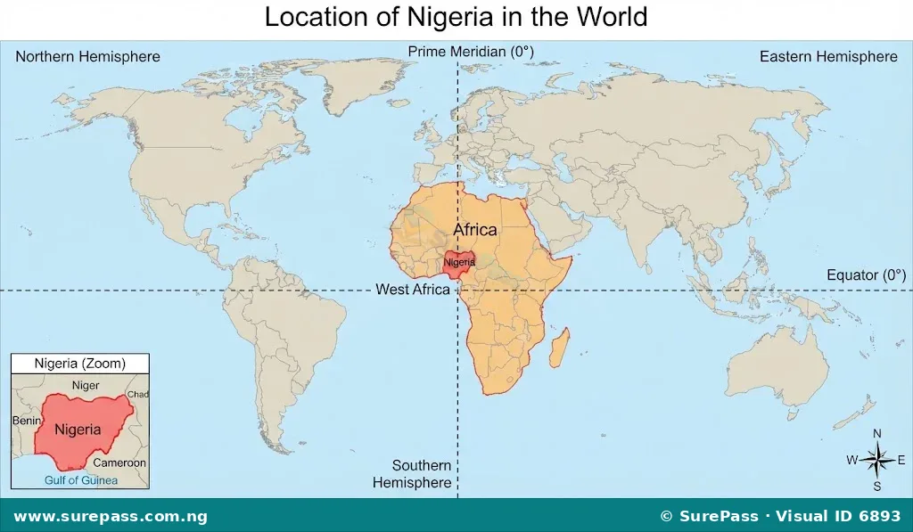
Nigeria is a country located in West Africa, on the continent of Africa. It is situated along the coast of the Gulf of Guinea, which is part of the Atlantic Ocean. This coastal location gives Nigeria access to important sea routes for trade and transportation.
On a global scale, Nigeria is found in the Northern Hemisphere and the Eastern Hemisphere. Its position in West Africa makes it a significant country within the region, influencing economic and political activities across the sub-continent.
Position of Nigeria using Latitude and Longitude
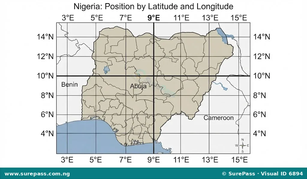
To precisely locate Nigeria, geographers use a system of imaginary lines called latitude and longitude. Latitude lines run horizontally around the Earth, parallel to the Equator, measuring distance north or south. Longitude lines run vertically from the North Pole to the South Pole, measuring distance east or west of the Prime Meridian.
Nigeria is located between:
- Latitude 4°N and 14°N (North of the Equator)
- Longitude 3°E and 15°E (East of the Prime Meridian)
These coordinates define the exact geographical boundaries of Nigeria, placing it firmly within the tropical zone of West Africa.
Nigeria’s Neighbouring Countries
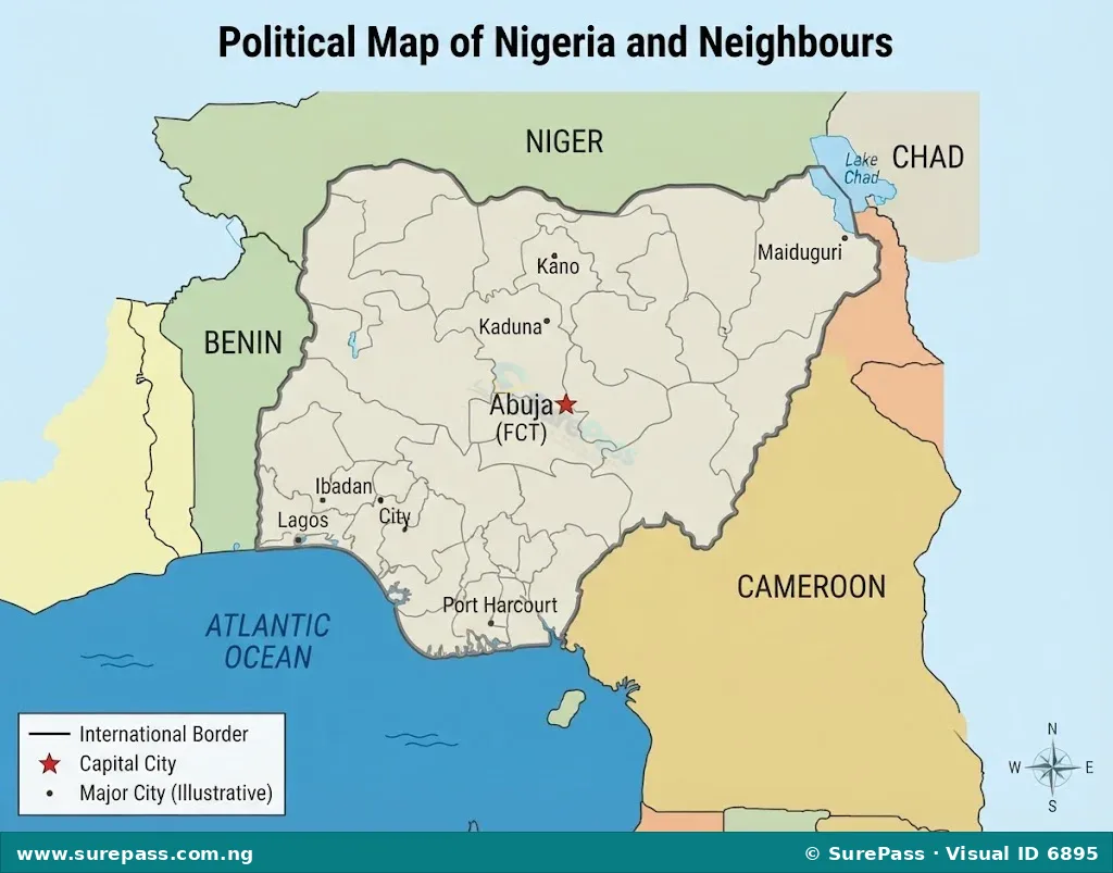
Nigeria shares land borders with four neighbouring countries. These shared borders facilitate cultural exchange, trade, and regional cooperation, but also present challenges such as border security and trans-border movements.
The countries that share borders with Nigeria are:
- Benin Republic: Located to the west of Nigeria.
- Niger Republic: Located to the north of Nigeria.
- Chad Republic: Located to the northeast of Nigeria, specifically sharing a border around Lake Chad.
- Cameroon Republic: Located to the east and southeast of Nigeria.
To the south, Nigeria’s border is formed by the Atlantic Ocean, specifically the Gulf of Guinea.
Size of Nigeria
Nigeria is a large country in terms of land area. Its size contributes to its diverse geographical features, varied climates, and large population.
The total land area of Nigeria is approximately 923,768 square kilometres (km²).
This makes Nigeria the 32nd largest country in the world by area and the 14th largest in Africa. Its extensive landmass supports a wide range of agricultural activities, natural resources, and human settlements.
Relief and Drainage of Nigeria
The relief of Nigeria refers to the variations in its land surface, including highlands, lowlands, and plateaus. Drainage refers to the natural systems of rivers and lakes that carry water across the land.
Major Relief Features
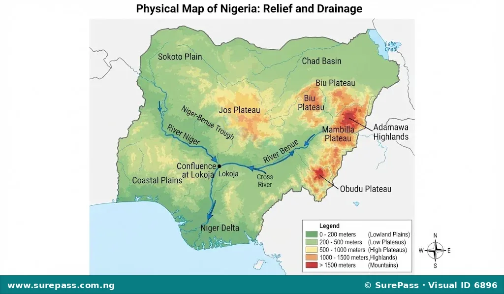
Nigeria’s landscape is characterised by a mix of elevated and low-lying areas:
- Highlands: These are elevated areas, often with rugged terrain. Major highlands in Nigeria include:
- Jos Plateau: Located in the central part of Nigeria, known for its high elevation and cooler climate.
- Biu Plateau: Found in the northeastern part of the country.
- Adamawa Highlands: Located in the eastern part of Nigeria, bordering Cameroon, and containing some of the highest points in the country.
- Mambilla Plateau: Also in the eastern part, known for its cool climate and rich agricultural potential.
- Obudu Plateau: Located in Cross River State, known for its scenic beauty.
- Lowlands: These are areas of low elevation, often flat or gently undulating. Major lowlands include:
- Coastal Plains: Stretching along the Atlantic coast, these are generally flat and swampy, particularly in the Niger Delta region.
- Sokoto Plain: Located in the northwestern part of Nigeria.
- Chad Basin: Found in the extreme northeastern part of the country, surrounding Lake Chad.
- Niger-Benue Trough: A significant lowland area formed by the valleys of the River Niger and River Benue, extending across the central part of the country.
- Plateaus: These are elevated flat areas, often with steep sides. Many of Nigeria’s highlands are also considered plateaus, such as the Jos Plateau and Mambilla Plateau. They are important for agriculture and provide sources for many rivers.
Major Drainage Systems
Nigeria is well-watered by several rivers and lakes, with two major river systems dominating its drainage:
- River Niger: This is the longest river in West Africa and the principal river of Nigeria. It enters Nigeria from the northwest, flows southeast, and then turns south to empty into the Atlantic Ocean through a vast delta. The River Niger is crucial for transportation, irrigation, fishing, and hydroelectric power generation.
- River Benue: This is the largest tributary of the River Niger. It enters Nigeria from the east, flows west, and joins the River Niger at Lokoja, Kogi State. This meeting point is known as the Confluence. The River Benue also supports agriculture, fishing, and transportation in its basin.
Other important water bodies include Lake Chad in the northeast and numerous smaller rivers and lagoons, especially in the coastal areas.
Drawing and Labelling Political and Physical Maps of Nigeria
Drawing and labelling maps are essential skills in Geography. They help in understanding and representing geographical information accurately. For Nigeria, you should be able to draw both its political and physical maps.
How to Draw and Label the Political Map of Nigeria
A political map shows administrative boundaries, such as country borders, states, and capital cities.
The procedure involves the following steps:
- Outline the Shape: Begin by lightly sketching the general outline of Nigeria. Pay attention to its distinctive shape, especially the western and southern curves and the northeastern protrusion towards Lake Chad.
- Add Neighbouring Countries: Draw the outlines of the neighbouring countries (Benin, Niger, Chad, Cameroon) where they border Nigeria.
- Mark the Capital: Locate and mark Abuja, the Federal Capital Territory, with a dot or star symbol.
- Draw State Boundaries (Optional for general map): For a detailed political map, lightly sketch the internal boundaries of Nigeria’s 36 states. For a simpler map, focusing on the country’s overall political structure is sufficient.
- Label Key Features:
- Label Nigeria clearly.
- Label the neighbouring countries: Benin, Niger, Chad, Cameroon.
- Label the Atlantic Ocean/Gulf of Guinea to the south.
- Label Abuja.
- Add Title and Scale: Include a clear title, such as “Political Map of Nigeria,” and a simple scale bar if specific distances are to be represented.
- Use a Key/Legend: If different symbols or colours are used (e.g., for capital, state boundaries), create a small legend to explain them.
- Neatness: Use a pencil for initial drawing and a pen for final outlines and labels. Ensure all labels are clear, legible, and correctly placed.
How to Draw and Label the Physical Map of Nigeria
A physical map shows natural features like mountains, rivers, plateaus, and lowlands.
The procedure involves the following steps:
- Outline the Shape: Start by drawing the accurate outline of Nigeria, similar to drawing the political map.
- Draw Major Rivers: Carefully draw the River Niger and River Benue, showing their main courses and their confluence at Lokoja. Also, include Lake Chad in the northeast.
- Indicate Highlands: Use shading, contour lines (if appropriate for the level), or specific symbols to represent major highlands such as the Jos Plateau, Biu Plateau, Adamawa Highlands, Mambilla Plateau, and Obudu Plateau.
- Indicate Lowlands: Use different shading or colours to represent lowland areas like the Coastal Plains, Sokoto Plain, and the Niger-Benue Trough.
- Label Key Features:
- Label Nigeria.
- Label the River Niger and River Benue.
- Label Lake Chad.
- Label the major highlands (e.g., Jos Plateau, Mambilla Plateau).
- Label significant lowlands (e.g., Coastal Plains, Niger-Benue Trough).
- Label the Atlantic Ocean/Gulf of Guinea.
- Add Title and Scale: Provide a clear title, such as “Physical Map of Nigeria,” and a simple scale.
- Use a Key/Legend: Create a legend to explain the symbols or colours used for different relief features (e.g., brown for highlands, green for lowlands, blue for water bodies).
- Neatness: Ensure the map is clean, accurate, and easy to read.



0 comments
Open the discussion when you need it. Comments stay collapsed until requested so the initial article remains light.