


ARTICLE CONTENTSOn this page 6 sections
Latitudes and Longitudes
Performance Objectives
By the end of the lesson, students should be able to:
- discuss the meaning of Longitude and Latitude;
- identify the major lines of Longitude and Latitude;
- describe the use of Latitude in the calculation of distances;
- describe the use of Longitudes in the determination of time zones on the Earth.
Introduction to Latitudes and Longitudes
The Earth is a large sphere, and to locate places accurately on its surface, a system of imaginary lines is used. These lines form a grid that helps in pinpointing any location precisely. This system is made up of lines of latitude and lines of longitude.
Imagine a giant, invisible grid drawn all over the Earth. This grid helps geographers, pilots, sailors, and even everyday people using GPS to know exactly where they are or where they need to go.
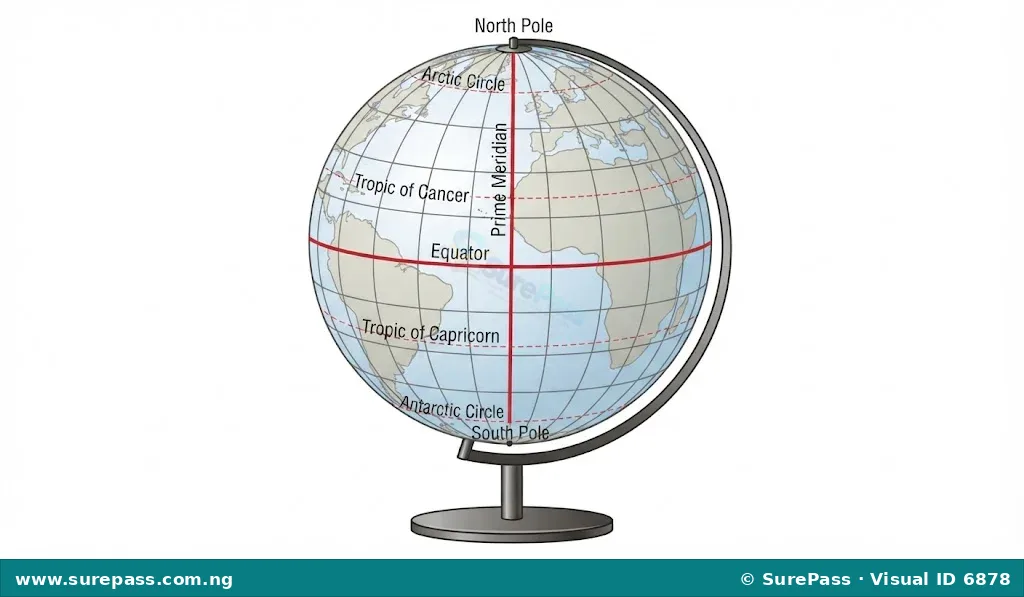
Meaning of Latitude
Latitude is the angular distance of a point on the Earth’s surface, measured in degrees, north or south of the Equator.
These lines are drawn horizontally around the Earth, parallel to the Equator. They are also called parallels of latitude because they never meet. The Equator is the longest line of latitude, and the lines become shorter as they approach the poles.
Major Lines of Latitude
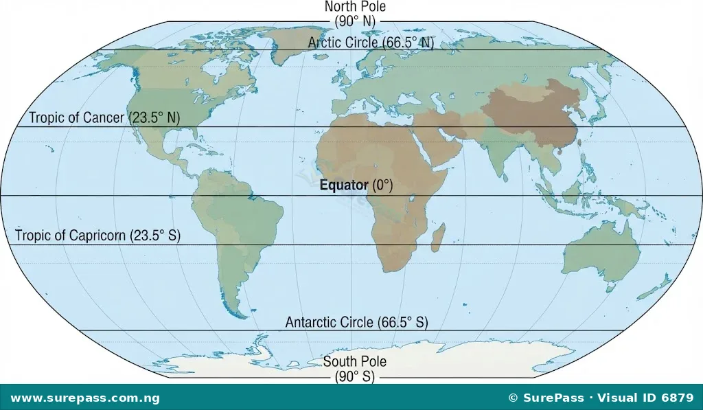
The Equator is the starting point for measuring latitude, designated as 0° latitude. All other lines of latitude are measured from this central line. Latitudes range from 0° at the Equator to 90° North at the North Pole and 90° South at the South Pole.
The major lines of latitude are:
- The Equator (0°): This is the most important line of latitude. It divides the Earth into two equal halves: the Northern Hemisphere and the Southern Hemisphere.
- Tropic of Cancer (23.5° North): This line marks the northernmost point where the sun’s rays can be directly overhead at noon. This occurs around June 21st, marking the summer solstice in the Northern Hemisphere.
- Tropic of Capricorn (23.5° South): This line marks the southernmost point where the sun’s rays can be directly overhead at noon. This occurs around December 21st, marking the summer solstice in the Southern Hemisphere.
- Arctic Circle (66.5° North): This line marks the southernmost latitude in the Northern Hemisphere where the sun can remain above or below the horizon for 24 continuous hours at least once a year.
- Antarctic Circle (66.5° South): This line marks the northernmost latitude in the Southern Hemisphere where the sun can remain above or below the horizon for 24 continuous hours at least once a year.
Latitude and Distances
Lines of latitude are used to calculate distances on the Earth’s surface, especially distances along a meridian (a line of longitude). Since all lines of latitude are parallel and the Earth is approximately a sphere, the distance between each degree of latitude is almost constant.
One degree of latitude is approximately equal to 111 kilometres (or 69 miles) on the Earth’s surface. This value is used to calculate the distance between two places located on the same longitude but different latitudes.
Calculating Distance Using Latitudes
To calculate the distance between two points on the same longitude but different latitudes, follow these steps:
- Find the difference in latitude:
- If both points are in the same hemisphere (both North or both South), subtract the smaller latitude from the larger latitude.
- If the points are in different hemispheres (one North and one South), add their latitudes together.
- Multiply the latitude difference by 111 km: This gives the approximate distance in kilometres.
Worked Example: Calculating Distance
Question: Calculate the distance between Lagos (6°N) and Kano (12°N) if both cities are approximately on the same longitude.
Solution:
- Find the difference in latitude:
Since both cities are in the Northern Hemisphere, subtract the smaller latitude from the larger one:
12°N – 6°N = 6°
- Multiply by 111 km:
Distance = 6° × 111 km/degree = 666 km
Therefore, the approximate distance between Lagos and Kano is 666 km.
Question: Calculate the distance between a point at 10°N and another point at 5°S, both on the same longitude.
Solution:
- Find the difference in latitude:
Since the points are in different hemispheres, add their latitudes:
10°N + 5°S = 15°
- Multiply by 111 km:
Distance = 15° × 111 km/degree = 1665 km
Therefore, the approximate distance between the two points is 1665 km.
Meaning of Longitude
Longitude is the angular distance of a point on the Earth’s surface, measured in degrees, east or west of the Prime Meridian.
These lines are drawn vertically from the North Pole to the South Pole, meeting at both poles. They are also called meridians of longitude. Unlike parallels of latitude, all meridians of longitude are of equal length.
Major Lines of Longitude
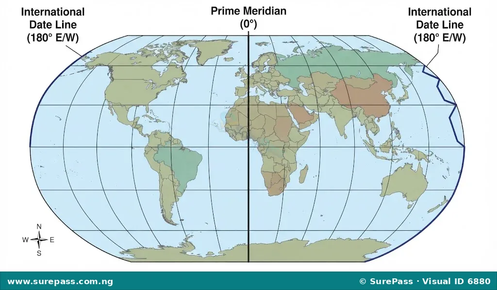
The starting point for measuring longitude is the Prime Meridian, also known as the Greenwich Meridian. It is designated as 0° longitude. Longitudes are measured from 0° to 180° East and from 0° to 180° West.
The major lines of longitude are:
- Greenwich Meridian (Prime Meridian) (0°): This line passes through the Royal Observatory in Greenwich, London, United Kingdom. It divides the Earth into the Eastern Hemisphere and the Western Hemisphere. All other longitudes are measured east or west of this line.
- International Date Line (approximately 180° E/W): This is an imaginary line on the Earth’s surface that runs roughly through the middle of the Pacific Ocean. It marks the place where one calendar day ends and the next begins. When crossing the International Date Line from west to east, one subtracts a day. When crossing from east to west, one adds a day.
Time and Time Zones
Longitudes are crucial for determining time and time zones. The Earth rotates 360° on its axis in approximately 24 hours. This means that for every 15° of longitude, there is a difference of one hour in time.
The calculation is as follows:
- Earth’s full rotation = 360°
- Time taken for one rotation = 24 hours
- Angular distance covered in one hour = 360° / 24 hours = 15° per hour
- Angular distance covered in one minute = 15° / 60 minutes = 0.25° per minute (or 1° = 4 minutes)
This relationship means that places to the east of a given longitude have a later time, and places to the west have an earlier time.
Calculating Time Using Longitudes
To calculate the time difference between two places using their longitudes, follow these steps:
- Find the difference in longitude:
- If both points are in the same hemisphere (both East or both West), subtract the smaller longitude from the larger longitude.
- If the points are in different hemispheres (one East and one West), add their longitudes together.
- Convert the longitude difference to time:
- Multiply the longitude difference by 4 minutes (since 1° = 4 minutes).
- Alternatively, divide the longitude difference by 15° to get the time difference in hours. If there’s a remainder, multiply it by 4 to get minutes.
- Adjust the time:
- If moving eastward, add the calculated time difference to the known time.
- If moving westward, subtract the calculated time difference from the known time.
Worked Example: Calculating Time
Question: If it is 12:00 noon at the Prime Meridian (0°), what is the time at a city located at 45° East?
Solution:
- Find the difference in longitude:
Difference = 45°E – 0° = 45°
- Convert to time:
Time difference in hours = 45° / 15° per hour = 3 hours
- Adjust the time:
Since the city is to the east of the Prime Meridian, add the time difference:
12:00 noon + 3 hours = 3:00 PM
Therefore, the time at the city located at 45° East is 3:00 PM.
Question: If it is 10:00 AM in Accra, Ghana (0° Longitude), what is the time in Abuja, Nigeria (7.5° East Longitude)?
Solution:
- Find the difference in longitude:
Difference = 7.5°E – 0° = 7.5°
- Convert to time:
Time difference in minutes = 7.5° × 4 minutes/degree = 30 minutes
- Adjust the time:
Since Abuja is to the east of Accra, add the time difference:
10:00 AM + 30 minutes = 10:30 AM
Therefore, the time in Abuja is 10:30 AM.
Identifying Latitudes and Longitudes on a Map
To identify latitudes and longitudes on a map or globe, observe the following:
- Latitudes: These are the horizontal lines running across the map from left to right. The Equator (0°) is usually the central horizontal line. Lines above the Equator are labelled with ‘N’ (North), and lines below are labelled with ‘S’ (South).
- Longitudes: These are the vertical lines running from top to bottom (North Pole to South Pole). The Prime Meridian (0°) is usually the central vertical line. Lines to the right of the Prime Meridian are labelled with ‘E’ (East), and lines to the left are labelled with ‘W’ (West).
When locating a specific point, its position is given as (Latitude, Longitude), for example, Lagos, Nigeria is approximately at (6°N, 3°E).



0 comments
Open the discussion when you need it. Comments stay collapsed until requested so the initial article remains light.