


ARTICLE CONTENTSOn this page 4 sections
Career Opportunities in Geography
Performance Objectives
By the end of the lesson, students should be able to:
- identify relevant career opportunities in Geography.
Understanding Career Opportunities in Geography
Geography is a broad field that studies the Earth’s surface, its physical features, climate, population, and how human activities interact with the environment. Because geography covers so many aspects of the world, it opens up a wide range of career opportunities in various sectors. A strong understanding of geographical concepts and skills can lead to exciting and impactful professions.
Many careers require geographical knowledge, even if they are not explicitly called “geographer.” These roles involve understanding spatial relationships, interpreting maps, analysing environmental data, planning land use, and studying human populations and their impact on the planet.
Specific Career Opportunities in Geography
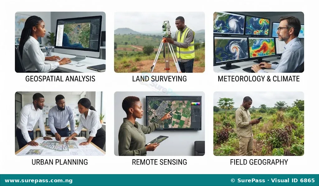
Studying geography can lead to many interesting and important jobs. These careers often involve using geographical skills to solve real-world problems, manage resources, plan communities, and understand environmental changes. Some of these career opportunities include:
Geospatial Analyst
A geospatial analyst uses geographical data, such as maps, satellite images, and location information, to identify patterns, trends, and relationships on the Earth’s surface. They use special computer software to process and interpret this data to help make decisions, for example, finding the best location for a new road, school, or hospital, or tracking the spread of a disease.
Urban and Regional Planner
Urban and regional planners are involved in designing and managing the growth and development of cities, towns, and regions. They create plans for land use, transportation systems, public services, and housing, aiming to create functional, attractive, and sustainable communities for people to live and work in. Their work helps ensure that cities develop in an organised way, considering environmental and social factors.
Landscape Planner
A landscape planner focuses on the design, management, and conservation of outdoor spaces. This includes parks, gardens, recreational areas, and natural landscapes. They consider the natural environment, ecological processes, and human needs to create functional and aesthetically pleasing outdoor spaces that are also environmentally sound.
Environmental/Emergency Consultant
Environmental consultants advise organisations and governments on how to protect the environment and comply with environmental regulations. Emergency consultants specialise in planning for and responding to natural disasters like floods, droughts, or landslides. They use geographical knowledge to assess risks, develop mitigation strategies, and coordinate emergency responses to minimise harm to people and the environment.
Climatologist or Meteorologist
A climatologist studies long-term weather patterns and climate change, while a meteorologist focuses on short-term weather forecasting. Both professions use geographical data, atmospheric science, and advanced models to understand and predict weather phenomena and climate trends. Their work is crucial for agriculture, transportation, disaster preparedness, and understanding global warming.
Digital Cartographer
A digital cartographer creates maps using computer software and digital tools. Unlike traditional mapmakers, they produce interactive maps, online mapping services, and digital atlases. Their work is essential for navigation apps, urban planning, environmental monitoring, and many other applications that rely on accurate and up-to-date spatial information.
Land Surveyor
Land surveyors measure and map the Earth’s surface to determine property boundaries, elevations, and features. They use specialised equipment to collect precise measurements, which are then used for construction projects, property development, legal documentation, and creating detailed topographical maps. Their work ensures accuracy in land ownership and development.
Remote Sensing Analyst
A remote sensing analyst interprets images and data collected from satellites, aircraft, and drones. This data provides information about the Earth’s surface without direct physical contact. They use this information to monitor changes in land cover, track deforestation, assess agricultural health, map natural resources, and study environmental phenomena over large areas.
Sustainability Expert
Sustainability experts work to help businesses, governments, and communities operate in ways that meet current needs without compromising the ability of future generations to meet their own needs. They use geographical understanding of resource distribution, environmental impacts, and human population dynamics to develop strategies for sustainable development, energy use, waste management, and conservation.
Public Health Consultant
Public health consultants use geographical information to understand the distribution of diseases, identify health risks, and plan healthcare services. They might map disease outbreaks, analyse access to healthcare facilities, or study environmental factors affecting public health. Their work helps to improve community health outcomes by identifying geographical patterns in health and illness.
Teaching and Research
Geographers also work in education, teaching geography at various levels, from secondary schools to universities. In research, they conduct studies to advance geographical knowledge, explore new theories, and find solutions to complex environmental and societal challenges. This career path involves sharing knowledge and contributing to the understanding of our world.




0 comments
Open the discussion when you need it. Comments stay collapsed until requested so the initial article remains light.